

Research
Climate Change
Climate change and extreme weather associated with increases in atmospheric carbon dioxide are critical issues that affect social systems, as they affect the global water cycle, ecosystems and biodiversity, or agricultural production, and lead to increased frequency of extreme events such as large typhoons and localized torrential rains, which require disaster prevention and mitigation measures. One of the measures to mitigate climate change is the REDD-plus initiative to protect forests that absorb carbon dioxide. Since verification observation of forests is essential for REDD-plus implementation, MOLI is expected to be an important tool to observe forests accurately.
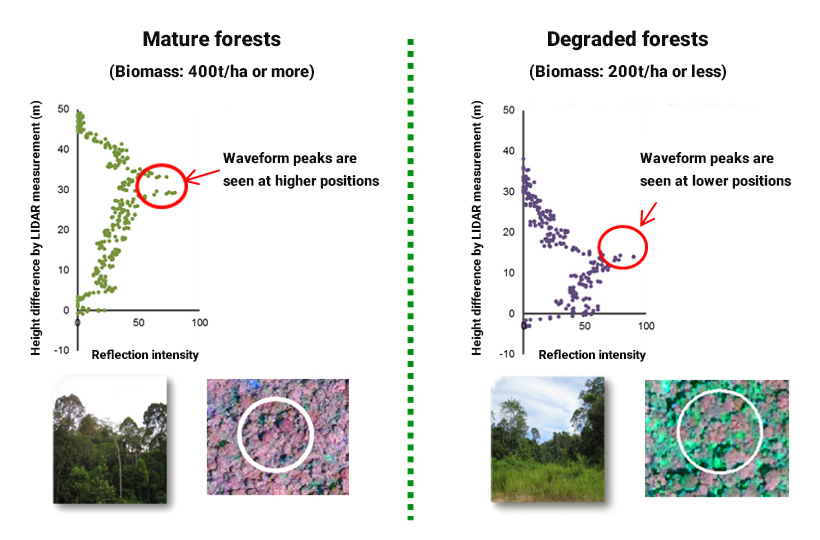
LIDAR can determine the three-dimensional structure of a forest. In particular, it is expected to assess the state of forest degradation based on observations of reflection intensity from the forest canopy at each level. The bottom figures show the results of satellite lidar ICESat/GLAS observations of a tropical forest where forest degradation has occurred in Sabah, Malaysia. By analyzing the shape of the waveforms, it is thought to be possible to identify the state of forest degradation1).
Observation of forest degradation is also effective for REDD-plus implementation, and MOLI is expected to be useful in this regard.
1) Environment Research and Technology Development Fund, D-1006, Maximizing the Co-benefits of REDD in the Biodiversity Conservation of Tropical Rain Forests
Biodiversity Research
Biodiversity has various definitions, but the Convention on Biological Diversity states that“Biological diversity refers to the variability among living organisms from all sources, and this includes diversity within species, between species and of ecosystems." Among these, forests are generally considered to be the ecosystems with the highest biodiversity. The more diverse a forest is, the higher its function.
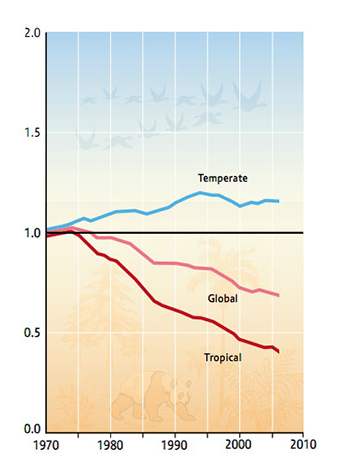
However, biodiversity is decreasing worldwide due to several factors such as global warming, desertification, human land modification, and invasive alien species.2) To prevent this, it is necessary to quantitatively and efficiently assess biodiversity over a large area, and the use of remote sensing technologies such as satellites is promising. Since it is difficult to measure biodiversity using remote sensing technology directly, observable parameters (e.g., tree height, forest structure, forest biomass) that can replace them are being studied.3)
If quantitative biodiversity indicators can be developed over a wide area using MOLI lidar waveforms and imager data, this information will be valuable in identifying forests and hotspots that require immediate protection.
- 2)
- Global Biodiversity Outlook 3, vol.16, no.6. 2011.
- 3)
- S. Goetz, D. Steinberg, R. Dubayah, and B. Blair, “Laser remote sensing of canopy habitat heterogeneity as a predictor of bird species richness in an eastern temperate forest, USA,” Remote Sens. Environ., vol.108, no.3, pp.254-263,
Contribution to Digital Elevation Model (DEM)
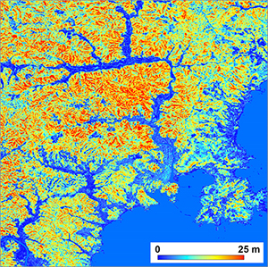
3D maps (AW3D) covering a global area have been developed using JAXA's Advanced Land Observing Satellite Daichi (ALOS/PRISM) and commercial satellite images. Due to increasing demand and applications, 3D maps are expected to become more accurate.
3D maps are created using photogrammetry based on satellite images, but photographs can only provide information on the image's surface layer (DSM). For example, in the case of development in forested areas, topographic information below the forest is important, but 3D maps created using image data that does not show the ground under the forest have low accuracy in topographic information.
To overcome this problem, LIDAR can acquire information on the elevation of the ground surface hidden by forests and contribute to improving the accuracy of 3D maps and ground surface height created by photogrammetry.